
Data-driven Model Puts Portland Policing Dynamics in Historical Context
In Portland, Ore., the Portland Police Bureau (PPB) responds to thousands of calls each year. These calls range from welfare checks and traffic incidents to more serious emergencies. Because the PPB has faced recent scrutiny regarding the overall effectiveness and fairness of their policing practices, the Bureau provides public access to data from dispatched calls throughout various neighborhoods to improve transparency. The following key questions guide the subsequent data exploration:
- In which neighborhoods do police calls most frequently occur?
- What are the defining characteristics of these neighborhoods?
- What factors might explain why certain neighborhoods experience higher call volumes?
Calls for service represent instances of police activity within a defined area and timeframe. Examples include dispatched calls, requests from the public via 911 or the non-emergency line, and self-initiated or directed calls where officers proactively respond to community issues. The PPB records all calls that involve at least one officer, primarily within city limits. These data reflect the total police response—i.e., calls that actually resulted in a dispatch—and are distinct from the Bureau of Emergency Communications (BOEC) data, which include all calls regardless of whether or not they led to police involvement.
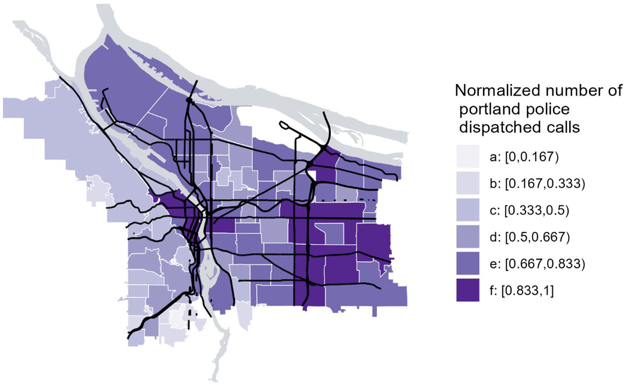
The PPB also provides access to dispatch call data. When the BOEC receives a call for service, dispatchers assign it a priority level based on the seriousness of the incident (e.g., low, medium, or high). This system helps determine the location and speed at which police are dispatched. The daily tallies of these calls for each neighborhood are then published to the PPB Open Data website.
Using the PPB dispatch call data, we tracked the number of calls for each neighborhood and applied the log transformation before we employed the min-max normalization method. This transformation method allowed for the meaningful comparison of relative changes across neighborhoods by reducing the influence of extreme values and placing all values on a consistent scale between zero and one.
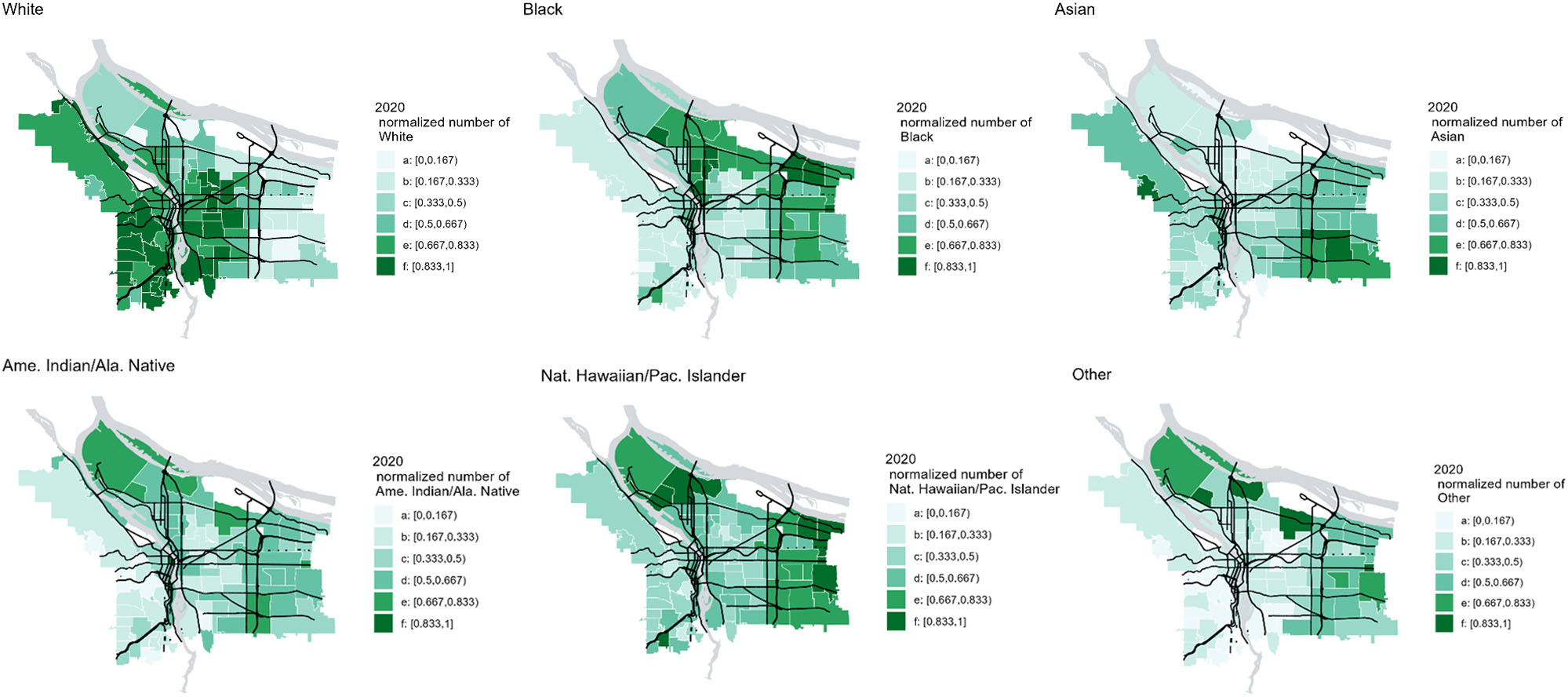
The neighborhood profiles from the Portland State University (PSU) Population Research Center include demographic and socioeconomic data from the 2020 census data. Using this data, we extracted the relative number of racial demographic categories for each neighborhood and transformed these numbers similarly to the PPB dispatch call data.
The maps in Figure 2 illustrate the racial composition and distribution of various Portland neighborhoods in 2020. We see that White neighborhoods are mostly concentrated in southeastern and central Portland, where the number of dispatched calls is less frequent. In contrast, non-White neighborhoods are predominantly located in northern and southwestern Portland — areas where the number of dispatched calls is higher.
Dispatch Calls Versus Demographics
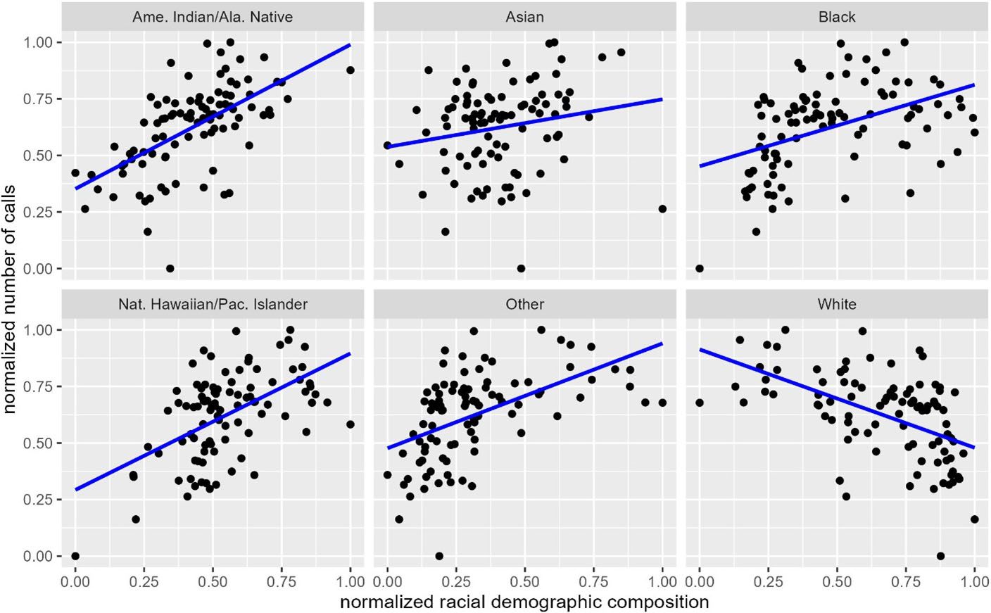
The scatterplots in Figure 3 quantify the apparent relationship between the racial composition of neighborhoods and number of dispatched calls.
Specifically, they confirm that neighborhoods with higher populations of non-White residents tend to experience more dispatched calls — a pattern that suggests a structural association between racial composition and police activity. While the data alone do not establish causation, the trend raises important questions about whether certain communities are subject to heightened surveillance or encounter a greater number of incidents that prompt calls for service.
One possible explanation for this pattern lies in the unequal distribution of socioeconomic resources across Portland. Neighborhoods with lower median incomes or higher unemployment rates often face enhanced exposure to environmental stressors, limited access to services, and elevated rates of reported incidents. These social conditions may increase both the need for police presence and the likelihood of residents contacting law enforcement.
A more nuanced interpretation must also consider the dual nature of calls for service. Not all calls reflect police-initiated enforcement actions; some are requests for assistance from residents themselves. Higher call volumes in certain neighborhoods might indicate increased community reliance on police services and the persistence of systemic inequities that necessitate such reliance. Given this complex relationship, it is important to view police call data not merely as an indicator of crime, but as a reflection of broader social and institutional dynamics.
Historical Context
One cannot realistically separate the spatial patterns of police calls in Portland from the city’s history of racial segregation and disinvestment. Beginning in the 1930s, federal redlining policies labeled Portland neighborhoods with Black and immigrant populations as “high risk,” restricting access to mortgages and public investment. These practices entrenched racial and economic inequalities that still persist today [1].
In fact, many of the neighborhoods that were historically subjected to redlining now show—at least in this modest data exploration—higher proportions of non-White residents and greater police activity. Although gentrification has shifted some populations outward, the legacy of exclusionary housing policies and past policy decisions continues to shape present-day residential patterns, the distribution of public resources, (including policing), and disparities in public safety.
Concluding Thoughts
This study seeks to understand where police calls occur most frequently in Portland, what defines those neighborhoods, and why disparities exist. Our results show that police dispatches are concentrated in neighborhoods with higher proportions of non-White residents and lower socioeconomic conditions — patterns that reflect current demographic differences as well as the lasting effects of historical segregation and disinvestment. As such, we found that broader structural and social factors influence calls for public safety service, which are not evenly distributed across the city.
Historical and socioeconomic factors are central to our greater understanding of the geography of policing in Portland. Effective addressal of these disparities requires policies that recognize the connection between community conditions and police activity.
Alex John Quijano delivered a minisymposium presentation on this research at the 2024 SIAM Conference on the Life Sciences, which took place in Portland, Ore., in 2024.
Acknowledgments: The author would like to thank the undergraduate researchers who helped with the data processing and visualizations in this study.
References
[1] Bureau of Planning and Sustainability (2019). Historical context of racist planning: A history of how planning segregated Portland. Retrieved from https://www.portland.gov/bps/documents/historical-context-racist-planning/download.
About the Author
Alex John Quijano
Assistant professor, University of Portland
Alex John Quijano is an assistant professor of mathematics at the University of Portland whose work centers on applied statistics and data science. His research interests include applying mathematics and statistics to interdisciplinary research problems in social sciences.

Stay Up-to-Date with Email Alerts
Sign up for our monthly newsletter and emails about other topics of your choosing.
